W. Salomon
Free University Amsterdam
Institute for Environmental Studies
Amsterdam, the Netherlands
Extended abstract
This presentation follows the title chosen by the organisers, and as such it may suggest a wider application than can be delivered: it is based on involvement in coastal projects for the past 25 years in Northern countries, European projects and global projects as well several individual projects dealing heavy metal, nutrients and pesticide issues.
The research questions from managers and policy makers in the past centred on the behaviour of individual substances or on the impact of management actions like dredged material disposal on contaminant behaviour. Very seldom were the social sciences involved. Currently the emphasis is more on integrated approaches involving both natural and social sciences. It should be noted that the Water Framework Directive also has strong integrative approaches. But first let us take a global approach on catchment-coastal zone interactions and how this integration is applied at the global level in projects like the LOICZBasins project of IGBP-LOICZ, followed by a consideration of European-wide approaches and finally at a regional project commissioned by the Port of Rotterdam.
The coastal zone is a dynamic area of natural change and of increasing human use. Coastal land is limited in area and under pressure from human development and, with the prediction that 75 % of the human population will inhabit the coastal zone by 2025, it is evident that an extreme competition for space with the ecosystem is occurring. Driving forces include population pressure, transport development, industry and tourism. This has led to urbanization (and mega-cities), increases in transport networks (canalization and harbours) and tourist sites, together with extensive sea defence and coastal protection works, at the expense of the footprint available for the ecosystem. Impacts include an increase/decrease in substance flow (e.g., sediments, water, nutrients and contaminants), loss of habitats and bio-diversity and related cultural assets. Apart from regional drivers and pressures in Europe itself, the changing coastal footprint is the result of global drivers and pressures including climate change.
The policy and management challenge is to ensure the sustainable utilisation of coastal resources under intense environmental change pressure. Our current limited understanding of the regional and global changes that impact on local coastal systems hampers addressing this challenge. At the local level these interacting challenges are fourfold:
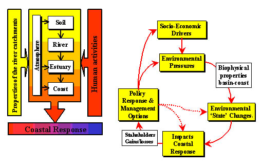
The Drivers-Pressures-States-Impact-Response (DPSIR) scheme, originally developed by the OECD, has been quite successful in combining natural and social sciences and offering participants in projects a common framework of analysis. In addition most of the impacts found in the coastal zone are derived from land-based (e.g. catchment activities), hence the land and the coast should be considered as one system (Figure 1). Results of the global assessment using this integrative approach can be found at: http://w3g.gkss.de/projects/loicz_basins/. Reports on Asia, Africa, South America, Russia etc. can be downloaded.
Figure 1. The catchments and the coast as one system and the Drivers-Pressures-States-Impact-Response framework.
This approach is used at the European scale in a study funded by the EU: The EuroCat project (http://www.iia-cnr.unical.it/EUROCAT/project.htm). Within the EuroCat the focus is on those impacts in the coastal zone resulting from changes in the flow of substances (contaminants and nutrients), which have their origin in the catchment.
The selection of catchments (a total of 8) and associated coastal seas is based on the wide diversity in biophysical conditions and socio-economic which exist in Europe. The Rhine represents transboundary issues and illustrates a context in which there is a well-documented and implemented plan at the catchment level. The Elbe catchment and associated estuary and coastal sea provides an example of a river system, which went through a relatively recent and rapid change in economic conditions in the catchment (central to market economy) with a corresponding change in fluxes to the coast. The Vistula and Provadijska catchments are undergoing similar changes albeit at a slower pace. The Axios is a complex example of agricultural and industrial impact on the catchment, also accompanied by the emerging problems of changing economy (central to market) in FYROM, where 95% of the upstream catchment belongs. The Po is a prime example of the impact of a catchment dominated by intensive agriculture on coastal sea functions and in particular tourism. In the Idrija of the impact on the coast of mercury pollution due to intensive past mining activities is studied. An important part of the project is to make predictions on future impacts on the coastal zone and cost-benefit analysis:nested scenarios are used to derive regional scenarios.
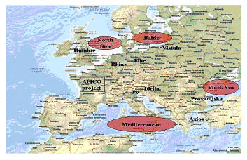
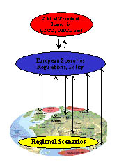
Figure 2. The catchments and coastal seas in the EuroCat study and the scenario development approach.
The results of the scenarios are used to drive the coupled models of for the catchment coastal sea continuum. For the catchments use is made of GIS-based models such as Moneris, which is coupled with coastal models such as Ersem. For the complex interface, between the coast and the catchments, the estuary, use is made of statistical models. A socio-economic model (Definite) is used for cost-benefit analysis of the scenarios. Integrated teams of natural and social scientists in each of the catchments carry out the project, with a total involvement of 24 European institutes.
Recently these approaches were used for a coastal zone management issue dealing with the disposal of dredged material from the Port of Rotterdam. The port of Rotterdam is located in the Rhine estuary and is a sedimentation area, being the interface between the Rhine and the North Sea. Marine sediments accumulate through tidal action in the western port areas whereas fluvial sediments, transported by the Rhine, mainly influence the eastern port sections. The sediment transport of the river Rhine is in the order of 3-4 million tonnes dry weight per year of which roughly half becomes deposited in the port and the remainder is directly transported to the North Sea.
To maintain adequate port facilities, 15 to 20 million m3 of sediments are dredged per year. The relocation of this dredged material to the North Sea, the preferred disposal option, is regulated by a set of so-called Sea/Slufter limit values. Dredged material exceeding these limits, mainly sediments from the eastern port areas, has to be disposed of in a confined site, the Slufter.
The sediments transported by the Rhine become contaminated by point and diffuse sources in the Rhine basin. Several heavy metals, polychlorinated biphenyls (PCBs) and polycyclic aromatic hydrocarbons (PAHs) have been and still are of concern. They frequently exceed the Sea/Slufter limits; hence this contaminated dredged material has to be stored in the Slufter. The “slufter” disposal site has a finite life-time. Hence the simple question was: What are the predictions for contaminant levels in the dredged material after 2010 and will it be possible to dispose in the North Sea (no need for building a second expensive disposal areas) again after 2010 in view of the then current regulations? To answer these questions it was necessary to build a mathematical model of the Rhine catchment with diffuse and point sources of contaminant input into the river system and to analyse the policy regulations on contaminant discharge in rivers, sewage, soil (German, Dutch regulations) as well the regulations on contaminant inputs in the North Sea. A policy analysis showed the complexity of regulations for the coastal zone as shown in Figure 3.
Figure 3 – Policies and regulatory frameworks related to issues directly
or indirectly influencing sediments/dredged material management in the continuum
system Rhine basin/coastal zone.
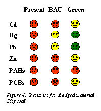
To answer the question of further developments several scenarios were set up and coupled with the mathematical model of the Rhine catchment in order to predict its future quality. These are regional scenarios derived from European and global scenarios (Figure 2). The results are summarised in Figure 4. BAU is the scenario for Business As Usual. The green scenarios refer to the implementation of all cost-effective measures decrease point and diffuse sources input. The fact that some contaminants still exceed the limit is due to presence of old contaminated areas in the catchment. PAH’s are derived from energy related processed (gas, oil, electricity etc) which are expected to increase despite measures.
Conclusion: As these examples show it is necessary to use
integrated approaches for coastal zone management. Population pressure is high
in the coastal zone, hence in “research for management” the joint
effort of both the natural and social sciences is a prerequisite. Coastal zones
are heavily influenced by land-based activities; hence the coast and the land
should be treated as one system.