Waleed Hamza *
Biology Dept. Faculty of Science, United Arab Emirates University. PO Box 17551
Al- Ain, UAE.
Permanent address: Dept. of Environmental Sciences, Faculty of Science- Alexandria
University. 21511- Alexandria, Egypt
Extended abstract
Although the aspects of both land use and coastal management represent part of the larger concept of sustainable development, the strength and interest with which these aspects are received varies considerably among countries. It is well known that land use planning can facilitate the allocation of land to those use(s) that provide the greatest sustainable benefits. However, in order to achieve a sustainable land use planning, an in-depth analysis of the existing resources is required (e.g. localization, features, sensitivity to development). Furthermore, the understanding of development characteristics (resource needs and collateral efforts), would make it possible to identify the use of natural resources. In that regard Sense and Toccolini (1998) mentioned that activities must be developed where the necessary natural resources exist and only when the environment is capable of absorbing the impact of that development.
Coastal management can be considered as a double-sided planning issue. On the one hand it forms a part of the land use concept, and on the other it deals with the conservation of aquatic ecosystems. That is why, in coastal countries, where high percentage of the population inhabits coastal areas, the management concept of coastal zones has become more pronounced than the land use concept. Moreover, the developed concept of Integrated Coastal Zone Management (ICZM) has recently been extended to include not only land use, but also the freshwater basins in coastal countries. This is because coastal managers have realized that the freshwater input to coastal areas has strong impacts on the coastal environments and the welfare of the population living in those areas. The physical and socio-economic relationship between the river basins and their corresponding coastal areas is also the basis for such integrated new approaches to sustainable development. This approach is developed by the UNCHS in Nairobi (1996) and is now known as the Integrated Coastal Area and River Basin Management (ICARM). The priority issues in this management approach are: capacity building, coastal land use planning, river basin development and recourses management, legislation enforcement, coastal and river banks protection and conservation (UNEP-MAP-PAP, 1999).
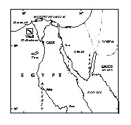
The concept of ICARM seems to add a new and important dimension to the previous concepts of land use and coastal zone management; especially in countries where surface freshwater resources play the major role in their development. In that regard, Egypt, as one of the third countries where the Nile River downstream runs in its territory from south to north may represent an ideal case study with which to apply the ICARM concept. The Nile River in Egypt has been the artery of life for its population from time immemorial. Moreover, any sort of development (agriculture, industrial, cultural, etc.) mainly depends on the availability of Nile water. The downstream flow of the river ends in Egypt with the Nile delta located between the two branches (Rosetta and Damietta) discharging Nile waters to the Mediterranean Sea through their estuaries (Fig 1).
Fig.1. Map of the Nile trajectory in the Egyptian Territory
Although Egypt owns the Nubian Aquifer, which is considered as a huge underground water reservoir, human activities and land use developments still depend on the Nile water availability. This is mainly because of the non-suitability of underground water for agriculture, and even for municipal purposes. Another factor which links the country development with the Nile freshwater availability is the population growth rate and the limited inhabited area of the vast Egyptian territory. As a matter of fact the Egyptian territory covers an area of about one million square kilometers. However, the Nile morphology and the barren deserts that bound the Nile valley and delta constitute a geographical barrier that prevents Egyptians from fully utilizing their territories. That is why about 99% of the population (total = 67 millions) is concentrated in 5.5% of the country area mainly located in the Nile valley and delta (Fig 2).
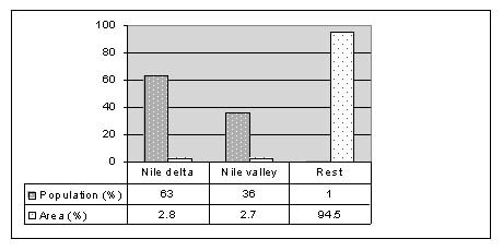
Fig.2. Percentages of Egypt’s population distribution
Historically, the socio-economic development of the country has been exclusively
restricted to the Nile valley and delta; which has led to high intensity of
population concentrated mainly in the capital (>20.000 person/km2). The main
constraint facing Egypt’s population is the availability of freshwater
resources, where the surface water available to the country is fully utilized
(Attia, 1999). That has encouraged the government to adopt different measures,
such as water recycling, and exploitation of underground water resources (Hamza,
2000). That is in addition to the actual use of modern irrigation techniques
and genetically modified seeds which grow with less water demands. Furthermore,
much effort has been made to identify the suitability of new lands to be used
for increasing the cultivated areas (e.g. GIS, EIS), as well as new technology
to be applied in water recycling which resulted in the reduction of freshwater
discharge to the Mediterranean. However, due to the population growth and the
consequent demands of living resources, Egypt has developed a number of land
use mega-projects. These projects aim mainly to enlarge the inhabitant area
of the territory, cultivate new lands and create job opportunities. As previously
mentioned the only constraint facing these projects is the availability of freshwater,
bearing in mind that the Egyptian quota of Nile water has not changed since
the Nile basin agreement signed in 1959 (i.e. 55.5 billion Km3/ year).
Examples of these mega-projects depending on the Nile water and its influence
on socio-economy are as follows:
A- The southern valley (Toshka) development project: the project aims are to create 2.8 million job opportunities (2000-2017) industry area, towns and various tourist attractions such as safaris and rallies. About 3 -6.3 million people would be able to find housing. Total investments by the year 2017 has been estimated as 80 billion US $, financed to 25% from the government and the rest through private investments. The Agriculture development is divided into different phases. The first phase, inaugurated in January 2003, is intended to reclaim 227.000 hectares from a longer term plan for 0.97 million hectares. The irrigation policy is mainly based on the pumping of the Nile water from Lake Nasser in the Toshka depression and mixing it with underground water. The utilized Nile water in the whole project is estimated to be 5.50km3/year (Mason, 2003).
B- Development of Sinai; the total population of Sinai is around 3.2 millions. The aim is to increase job opportunities to 800.000 by year 2017. The total investment is 20 billion US $. The agriculture plan is divided into several phases. In Phase 1 about 168.000 hectares are to be cultivated with the utilization of 3 km3/year of freshwater, to be obtained from the El-Salam canal, which is formed of 50% of recycled water and 50% of Nile water (Mason, 2003).
The above examples show to what extent Egypt is seriously counting on both groundwater exploitation and recycled water utilization. These issues will certainly reduce both the quantity of freshwater discharges to the Mediterranean and the quality of the discharged water. Consequently, disturbance to the marine ecosystem will be the main problem that has to be one of the top priorities for coastal area managers. In that regard different efforts have been devoted to evaluating the coastal water quality and ecosystem behaviour due to variations in both the quantity and the quality of the land run-offs. Satellite images of land run-off discharges to the Mediterranean have shown the impact of the degraded water quality on the coastal lakes, actually acting as transitional basins for sewage before its discharge to the Mediterranean Sea (Fig.3).
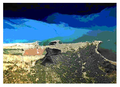
Fig3. Eutrophication of Alexandria coast by sewage discharge (c.f. Halim and Abu-Shouk, 2000).
The numerical simulation of the coastal ecosystem variables has also indicated
the formation of algal blooms during winter season, a phenomenon that has developed
along the Egyptian coasts since the construction of the Aswan High Dam (Dowidar,
1984, El-Sayed and Van Dijken, 1995). Such blooms result from the water quality
of the discharges from land sources (Hamza et al., 1998, 2003). These conditions
show that the coastal marine environment of the Egyptian Mediterranean Sea has
become the final basin into which all wastewaters deriving from different human
activities are discharging.
At present, it is clear that there is a close link between land use in coastal
countries and the influence of the river basin on coastal zone management. However,
the economic situation of the country has to be considered as the main factor
influencing the their strategic plans to realize the concept of sustainable
development. It has to be remembered that, although environmental laws exist
in many developing countries; the tools for their application are either inefficient
or lacking in substance, mainly because of the economic situation. It is therefore
not unreasonable to consider sustainable development in the third countries
as a challenge. However, in many countries, such as Egypt, such a challenge
has to be met by the adoption of new technologies, economic development and
demographic growth control.
References
Attia, F.A.,1999. Role of groundwater in Egypt. Economic development. Proceedings
7th
2002 Nile conference 15-17 March, Cairo, 1999. Egypt, 11:1-16 pp.
Dowidar, N. M., 1984. Phytoplankton biomass and primary productivity of the
south-eastern Mediterranean. Deep-Sea Research. 31: 983-1000
El-Sayed, S. Z.; and G. L. Van Dijken, 1995. The southeastern Mediterranean
ecosystem revisited: Thirty years after the construction of the Aswan High Dam.
Ocean. Dept. Texas A & M Univ. Quarterdeck Vol. 3.1.
Halim, Y. and F. Abu-shouk, 2000. Human impact on Alexandria’s marine
environment. In: (eds.) Mostafa, H. M; N. Grimal and D. Nakashima (2000), Underwater
archeology and coastal management, focus on Alexandria. UNESCO, 2000.
Hamza, W, 2000. Economic development and compensatory measures related to the
management of the Egyptian water resources. UNESCO Annual book, Water security
in the third Millennium. Mediterranean countries as a case. Science for Peace
Series. Vol. 9: 453- 470.
Hamza, W, P. Ennet; and R. Tamsalu. 1998. The ecosystem calculation for the
Egyptian part of the Mediterranean. In: Tamsalu, R. (Ed.), the coupled 3D hydrodynamic
and ecosystem model FinEst. M. E. R. I. 35: 143- 148.
Hamza, W., P. Ennet; R. Tamsalu; and V. Zalesny, 2003. The 3D physical-biological
model study in the Egyptian Mediterranean coastal sea. (Accepted, J. Aquatic
Ecology).
Mason, J. A. S., 2003. From conflict to cooperation in the Nile basin. Ph.D.
Thesis submitted to Swiss Federal Institute of Technology, ETH- Zurich.
Sense, G., and A. Toccolini, 1998. Sustainable land use planning in protected
areas in Italy. J. landscape and urban planning. 41: 107-117.
UNCHS, 1996. Issues in integrated planning and management of River/Lake basins
and coastal areas: A human perspective. Nairobi: UNCHS.
UNEP-MAP-PAP, 1999. Conceptual framework and planning guidelines for integrated
coastal area and river basin management (ICARM). Split, Priority Action Program.
UNEP/MAP/PAP.